CLUTTON - Clutton is an ancient parish, mentioned in the Domesday Book as Clutone. The manor of Clutton was one of the many gifts William the Conqueror bestowed on his supporters, in this case the Bishop of Coutances, who held it until his death in 1093. The earliest known incumbent of Clutton church was Robertus, who was instituted in 1308, and since that time the continuity has been almost unbroken, a list of incumbents is displayed in the Church.
Clutton church is dedicated to St Augustine who was Bishop of Hippo Regius, which is a North African port near the city of Annaba in Algeria. Augustine became Bishop in 395 AD and served until his death in 430 AD, possibly from starvation, during the siege of the city by the East Germanic tribe known as the Vandals.
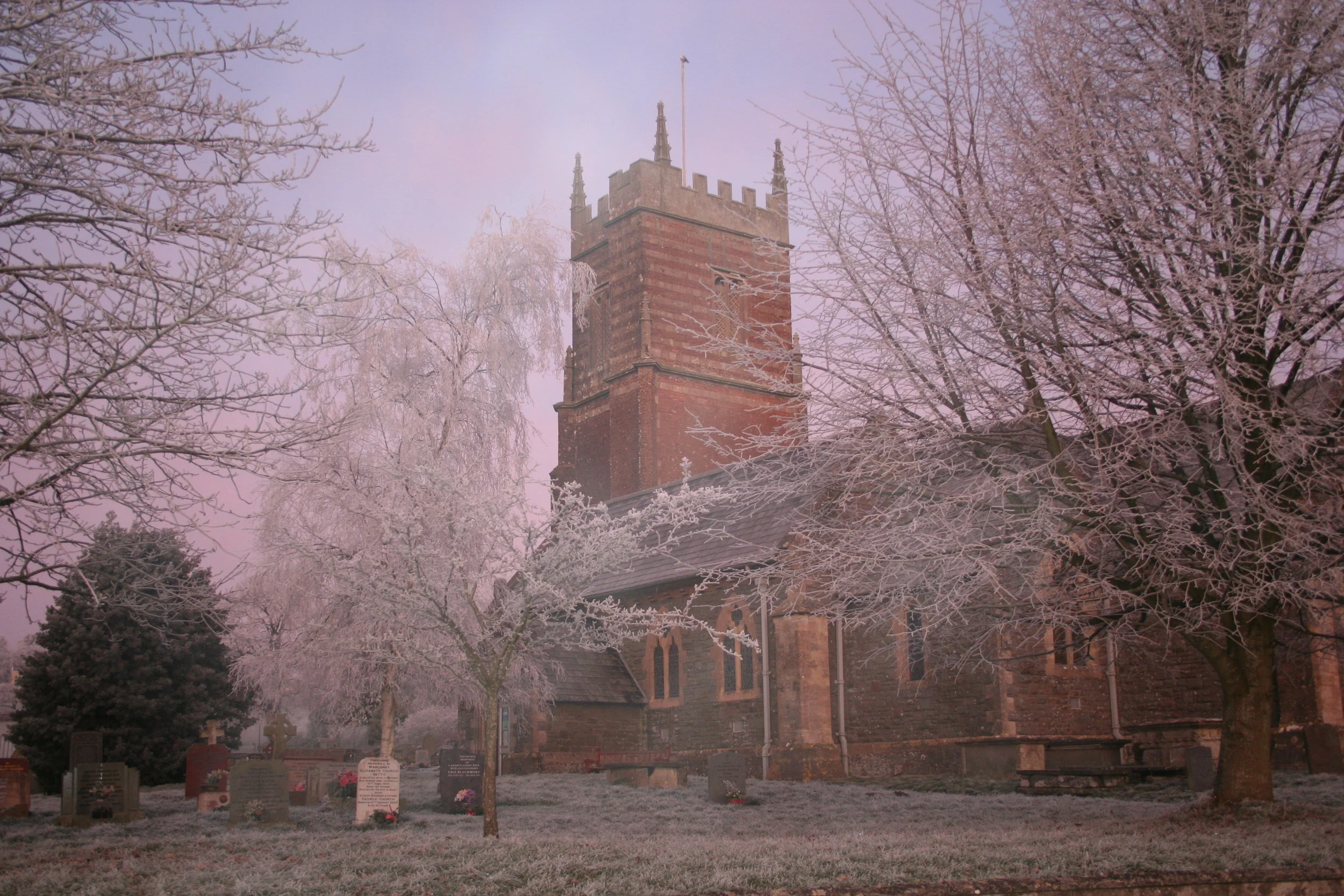
The church and tower are grade II* listed and originate from the twelfth century but only two parts of the building remain from that date: the inner arch of the entrance porch and the chancel arch. The body of the Church was rebuilt in 1865 by John Norton. The 15th century tower was rebuilt in 1728 although some of the older portions remain, it has unusual and striking red sandstone banding. The tower houses 6 bells the oldest being cast in Bristol in 1680. The church has benefited from two significant grants funded by the National Lottery, these have enabled the roof to be completely replaced in 2009 and the tower stabilised in 2018/19.
At the West end of the church is an oak gallery erected in 1970 housing a pipe organ that bears the inscription “Presented by the Earl of Warwick 1856.” The organ came from Warwick Castle and was previously installed in the area that is now the Lady Chapel.
The pulpit and font are of stone and both date from the 19th century. Inside the vestry is a plaque in memory of Mrs Ann Harris who set up a trust for poor relief. It reads: “Mrs Ann Harris of this parish, widow who died on the 27th day of March 1860, aged 89 years, gave in her lifetime to the trustees, the yearly rent charge of 1.5 [possibly shillings] upon trust. After her decease to pay and apply the same yearly for ever at Christmas in conjunction with the minister and churchwardens for the time being of the said parish of Clutton for providing undergarments for poor women of the said parish of Clutton, being upwards of sixty years of age”.
In the churchyard there are 5 Grade II listed monuments (reference no. 1129586), some of these relate to the Bodribb family. The Brodribbs were the grandparents of Sir Henry Irving, the first knight of the English stage. It is said that Irving rehearsed his first play in the sitting room of Maypole Farm in Clutton. There are also war graves in the churchyard, as listed by the War Graves Commission. Plague graves are believed to be to the North of the church.
John Wesley preached at the Church on four occasions, the first in 1780. When he visited Clutton in later years he was refused permission to preach inside the Church and so preached from a tombstone in the churchyard.
The trustees of a charity, set up with a legacy of £200 from a Mr. Perry and a bequest of £93 by a Mr. Adams, founded a free school in 1728. This was for the teaching and apprenticing of ten poor parish boys and a schoolmaster was paid £13 per year. It is not known where this school was situated, but, comparing a series of maps and information from a Charity Commission Report, it appears to have been an existing church property, perhaps a barn on glebe land, on the present Bristol Road, A37.
In 1604 it had been made compulsory for schoolmasters to be licensed by the local Bishop, though many taught illegally, especially in rural areas. The restoration of the monarchy in 1660 resulted in a further tightening of Anglican control on schools with the 1662 Act of Uniformity requiring licences to be recorded in Bishops’ Subscriptions books. In 1763 it is recorded in the Subscriptions Book of the Bishop of Bath & Wells that a Schoolmaster, James Leman, was, ‘licenced to keep and serve the Charity School in the parish of Clutton … [promising that he] … will conform to the liturgy of the Church of England’.
In 1811, National Schools were set up, based on the work of the Reverend Andrew Bell and his experiences of teaching the orphan children of soldiers in Madras, India. The idea was that large numbers of children could be taught by one teacher with the assistance of low-paid monitors or pupil teachers, which meant that schools were cheaper to run. The teaching focussed on reading, writing, arithmetic and Anglican religious instruction. Clutton was in the forefront of this movement. In 1839 a new school was built on land donated by the Earl of Warwick. A schoolmaster’s house was built next to it, on church glebe land, in about 1875. The school and schoolhouse are now private homes.
The National School was closed when a new school was built in 1902, with Lady Warwick laying the foundation stone. This larger school, initially called Clutton Council School, was built for 330 children. Until 1935 it was an elementary School and was for all ages up to 14 years old. The badge on the dark green school uniform includes a swan, which is from the family crest of the Warwick family.
Until the 20th century, there were no welfare benefits to help individuals or families, so poor people were dependent on charity. Towards the end of the 18th century Workhouses were set up for the poor and destitute. Very often whole families ended up in these institutions, where men, women and children, even from the same family, were separated and led extremely hard lives. The Clutton Union Workhouse opened in 1836 and the Salaries Ledger shows that Miss Dury received a salary of £20 per annum in 1881 for teaching thirty seven children, though a few attended local schools. This Workhouse closed in 1930 and the building was eventually converted into housing.
In 1662 the Reverend Matthew Afflat was ejected from St. Augustine’s church for refusing to read The Act of Uniformity, an act which required priests to follow all the rites, ceremonies and doctrines present in the Anglican Book of Common Prayer. Two thousand Church of England clergy were ejected from their churches at this time. This was followed by the Five-Mile Act, which prevented ejected priests from preaching within five miles of their previous churches, so Afflat’s followers built a chapel at Chelwood. In 1813 the Congregational Chapel or Independent Chapel was built and opened at the top of Church Lane in Clutton. The services were well attended and records report that in 1851 one hundred and fifty attended in the morning and two hundred in the evening.
CAMELEY - Cameley is an ancient village lying on Cam Brook. It was listed as Camelie in the 1086 Domesday Book and the name means 'the curved river meadow' from the Celtic ‘cam’ and Old English’ lea’. The Domesday entry reads: The Bishop (of Coutances) holds Cameley himself. Two thanes, (Sheerwold and Ordwold), held Cameley before the Conquest. It paid tax for 9 hides and half a virgate of land. Land for 9 ploughs. In lordship 3 ploughs; 13 slaves; 4 hides and 3 virgates. 9 villagers; 1 smallholder; 7 cottagers with 4 ploughs and 3 hides and 1.5 virgates. A mill which pays 5s; meadow 120 acres; pasture, 30 acres; underwood 50 acres. 2 cobs, 12 cattle, 21 pigs, 150 sheep. The value was £7; now £10. Humphrey holds: 1 hide of this manor’s land; he has 1 plough there, in lordship. 3 villagers and 1 cottager with 1 plough. Meadow 40 acres. 12 cattle; 14 pigs; 10 sheep; Value 20s. Though we still use acre as a unit of land measurement today, the hide and the virgate have fallen out of use. It has been estimated that the land area of the manor of Cameley in 1086 was probably between 1600 and 1700 acres, so very similar to today. There could have been between 30 and 40 dwellings, with a population of about 100 – 150 people. Cameley had one mill, probably downstream from the site of the church. The church of St. James may or may not have been there. The Domesday Book makes no reference to churches generally. It is likely that there was a place of worship here and it probably was on the present site of St. James, but at best it would have been a small stone structure or something a little larger in timber.
About 1150 the manor was given to Bath Abbey by the Alnes (or d'Alneto) family. In the 13th century it was held by the Marisco family and then passed into the control of the Knights Templar, which was confirmed in a grant of 1201. During the 13th and early 14th century the manor was again under the control of the de Marisco family. On the south post of the chancel arch in Cameley Church is a coat of arms with two red chevrons, which is believed to be of the St Maur family. Almeric de St Maur was master of the Knights Templar in England and put his seal on the Magna Carta. The coat of arms represents further evidence of the link between Cameley and Temple Cloud to the Knights Templar.
TEMPLE CLOUD - Temple Cloud is relatively modern village and is predated by Cameley in whose parish it sits. Temple Cloud’s growth was probably due to the building of what became the turnpike road from Bristol towards Shepton Mallet, now the A37, which was also part of the reason for Cameley’s decline in importance. There was a manor near the junction of Cameley Road with Bristol Road and a number of cottages were added over the years. At the Green was a pub called The Bell and the village cross was on the site of what is now the traffic island.
Temple, historically, may relate to the Knights Templar. These were, probably, the most famous of the Western Christian military orders. This organization of warrior monks was originally founded, in 1119, to protect pilgrims travelling in the Holy Lands. The Order became a favoured charity in all Christian Kingdoms and grew rapidly in membership, wealth and power. Templar knights, in their distinctive white mantles with an embroidered red cross, were among the most skilled fighting units of the Crusades. Temple Cloud has old field names containing the word “Temple” and there is evidence that the Knights Templar held land at Cameley 1201 and were paying taxes here in the early 14th century. Cloud certainly pre-dates the Templars or ‘Temple’ part of the name, as there are documents referring to “Cloude” or “La Clude” in the archives. Some suggest the name comes from the personal name of “Cloda”, who may have owned the land in Saxon times. More probable is that it comes from the Old English word ‘clud’, meaning a mass of rock or a rocky hillside. This definition may also be linked to the name of Clutton.
In 1902 there was an Inn, a Post Office, a school, a Court House, a plumber, a grocer, a blacksmith, a baker, a butcher and a wheelwright in the village. There was also a Superintendent and two police constables in the Police Station that was part of the Court House. The first school was built to hold 100 children in 1861, on land on the opposite side of the main road to the Temple Inn. It had two classrooms; one that was 12 x 5.5 metres in size and another that was 5.5 x 4.5 metres (quite small by today’s standards). It also had two very small cloakrooms, but it had no indoor toilets, staffroom, office or hall. It was heated by one coal fired boiler.
During the 1914 – 1918 World War 1, no mention was made of the conflict in the school Log Book. During the Second World War, however, there are many mentions. From 1st to the 18th September 1939, for example, the school was closed so that it could be used to welcome children who had been evacuated from London. This was because there was less danger of bombing in rural areas. These, and the other evacuees who followed over the next few years, were taken in by local families, sometimes staying for several years. By 1941, there were 39 evacuees staying with families locally. When school dinners started being served, in December 1943, the school children had to eat them at their school desks as there was no hall or dining room. A very unusual and exciting development was the building of an outdoor swimming pool together with proper changing room facilities, that opened in 1973/4. This meant that all the children could learn to swim. It was also open to use during the summer holidays.
Overcrowding, an aging building and the lack of appropriate facilities had been a growing problem for the staff and children in this old school over time. Eventually, after many years of discussion and planning, the school moved to a brand new building, in Meadway, in January 1994. This is still in use today.
References: Pevsner, Buildings of England, J. Collinson, History of Somerset 1791, Benjamin + Beauchamp, architects, Wedmore, Somerset, Clutton History Group, A Children’s Guide to the Parish of Clutton with Cameley by Lorna Boyd.
